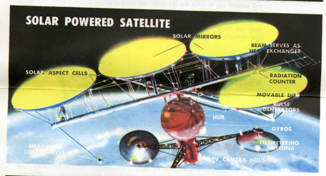
One of the great space posters of the late 1950's was the 1958 Hammond Space Map. Produced by the Hammond Map Company it has gorgeous paintings of space vehicles.
Because the map is 29" x 42" inches it is hard to scan but I have been lucky enough to acquire a very nice copy as a part of this "Hammond's Space Kit" set:
The folded map looks like this (which may be the way most of you have seen it):
This map is almost a book within itself. The entire backside of the map is covered in text explaining the images on the front. Here is one shorter example of the text. The real treat however are the illustrations.
Any one of these mini-paintings would make a great screensaver (remember to click on the image to enlarge it). Here are the satellites:
Here you see the solar powered satellite circle the Earth.
The details and labeling make each image a fascinating combination of engineering design and romantic illustration.
And our favorites: the Space Taxi, Space Station, and Moon Base
I can't forget the rockets and astronauts can I?
All in all this map is a real treat that I am glad to share. These illustrations were reused by Hammond in other publications including this one that I blogged about here:
Here is one last one to leave you with, The Interplanetary Ship Central Control. Be sure to read all of the labels since I am not exactly sure what a "Uloranoben" is supposed to do. Please comment if you have any idea.


First, I'm guessing that the "Interplanetary Ship Central Control" is located in the "main ship" section of the "TV Satellite." In other words, it's an orbiting mission control for flights to the Moon and Mars. ("Satellite" referred to pretty much anything in orbit back then, and TV communication was futuristic communication.)
ReplyDeleteThe "Uloranoben," located in the same console with a solar aspect plotter and a radar plotter, might break down like this (keeping in mind its name was probably coined by a rocket scientist who mixed his native German with his adopted English). U-loran-oben. "Loran" is an acronym for "LOng RAnge Navigation." "U" might stand for "ultra" or "universal" (indicating something different from the terrestrial LORAN system). "Oben" in German means "above" or "ahead." So: ultra/universal long-range-navigation above/ahead.
That's my theory, anyways, and I'm sticking to it. Until I give it up. :-)
I had one of these! I loved it, and the National Geographic's Map of the Heavens.
ReplyDeleteThanks so much for making this available. I really enjoyed this poster as a space-loving kid, and I've been looking for it ever since then. Happy Rockets, everybody!
ReplyDeleteJUST FOUND ONE YESTERDAY AT AN ESTATE SALE FOR $5 IN INDEPENDENCE MO. WoW, FEELING LUCKY! Thanks for posting this!
ReplyDeleteMine bit the dust with the cellophane tape on the folded parts....but I have my husband's map. Just showed my son it as he was showing me new photos of "new" planets found beyond Pluto.
ReplyDeleteI raked leaves for two weeks to get the money to send away for this (if I'm not mistaken--and I may well be--it cost me fifty cents). Well worth the cost and toil. I had a Gilbert 40X telescope at the time; between that and the map, I daydreamed quite a few afternoons away in outer space, where I thought I'd go some day. Then I became an English professor. Life is full of ironies.
ReplyDeleteCan you order newer versions? I have 1958 poster. Is this company still in business
ReplyDeleteI have 1958 poster. Is this place still in business and do they have a more up to date poster?
ReplyDelete